
Drone Footage Above Mount Everest [5 Stunning Frames You Must See]
Introduction
On October 11, 2025, a post by @wonderofscience stunned the internet. The tweet showcased breathtaking drone footage captured above Mount Everest, filmed by DJI, marking one of the most extraordinary aerial achievements in modern times. This video offers more than visuals — it’s a rare fusion of human ambition, technology, and nature’s power, all above 9,200 meters.
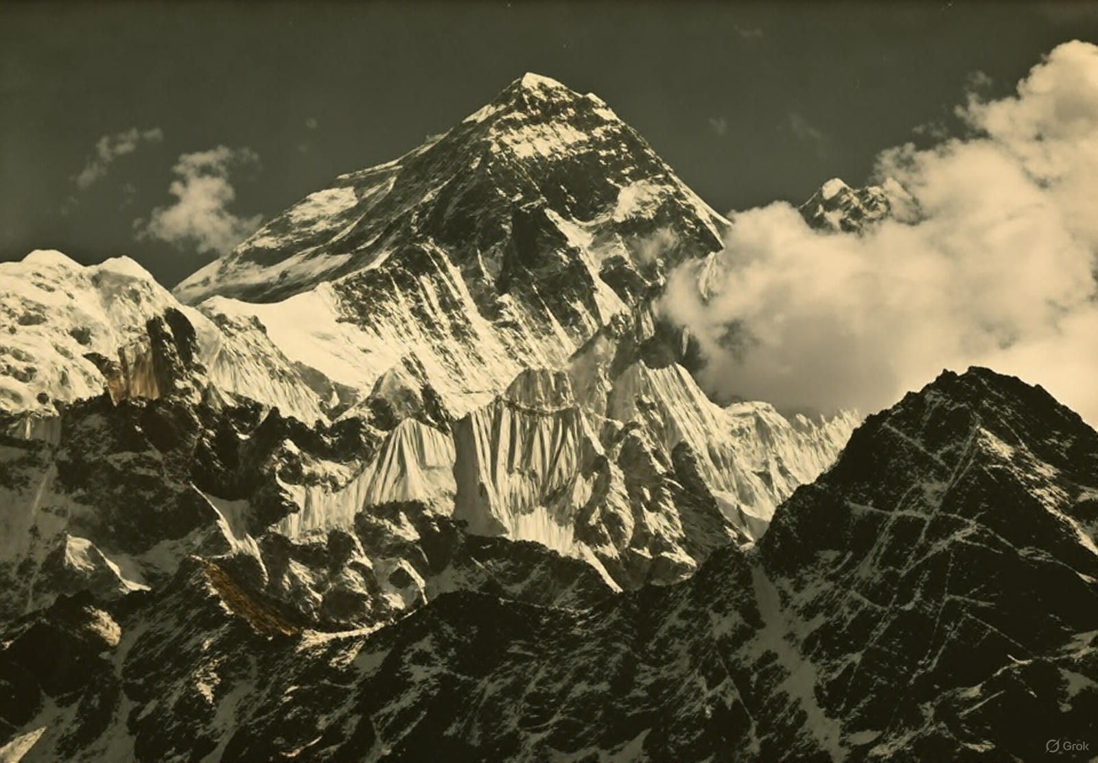
Drone footage from above Mount Everest, the highest peak of the world.
— Wonder of Science (@wonderofscience) October 11, 2025
📽: DJIpic.twitter.com/U7MxTc8D9j
A Viral Tweet that Took the Internet to New Heights
The tweet, shared at 20:51 IST, included multiple still frames from the DJI drone’s video, showing Everest’s snow-capped peak and the surrounding Himalayan expanse. Each image captured a precise altitude reading, chronicling the drone’s ascent from 8,848 to over 9,200 meters — higher than any mountain on Earth.
“Drone footage from above Mount Everest, the highest peak of the world. 📽: DJI”
The video link quickly went viral, amassing millions of views and sparking discussions about how drone technology has evolved to conquer nature’s most extreme environments.
A Frame-by-Frame Breakdown of the Record Footage
1. The Launch (8848.86 m)
At the summit of Mount Everest, a climber in red gear sits on snow, preparing to release the drone. The colorful prayer flags flutter in the freezing wind — a symbol of spirituality meeting science.
2. The Ascent (8852–9003 m)
As the drone climbs higher, it captures breathtaking shots of Earth’s curvature and the crisp blue Himalayan sky. Lens flares from the sun add drama, while the drone’s telemetry showcases steady gains in altitude.
3. The Midway Marvel (9046–9159 m)
The drone continues its rise, capturing the rugged terrain, icy cliffs, and snow-laden ridges that define Everest. Each frame tells a story of extremes — freezing temperatures, low oxygen, and breathtaking beauty.
4. The Stratospheric Stretch (9167–9232 m)
Beyond the summit, the drone enters near-stratospheric altitude, hovering over the clouds. The peaks below shrink into the horizon, resembling white waves frozen in time.
5. The Final Panorama (9232.91 m and beyond)
The final sequence showcases an awe-inspiring 360° view of the Himalayas — majestic, infinite, and humbling. The drone captures a perspective humans have only dreamed of, redefining how we perceive exploration.
The Significance: When Technology Touches the Sky
Capturing footage above Mount Everest is not merely an engineering accomplishment — it’s a symbol of human resilience and innovation. At such altitudes, air density drops to one-third of sea level, making drone stability, battery life, and control immensely difficult. DJI’s feat proves how modern aeronautics and AI flight systems are reshaping exploration.
This footage isn’t just for visual pleasure — it’s data-rich. Altitude readings, wind movement, and temperature gradients contribute to scientific understanding of the Earth’s upper troposphere.
FAQs
1. Who captured the drone footage above Mount Everest?
The footage was filmed by DJI, one of the world’s leading drone manufacturers, and shared on X (formerly Twitter) by the account @wonderofscience.
2. What altitude did the drone reach?
The video shows the drone reaching approximately 9,232.91 meters, surpassing Everest’s official height of 8,848.86 meters.
3. Why is this footage important?
It represents a historic milestone in drone engineering and high-altitude photography, showcasing how far unmanned flight technology has progressed.
4. Is the footage real?
Yes — the video and altitude data are consistent with DJI’s official capabilities, and the visuals match verified satellite imagery of Everest’s summit region.
5. Can regular drones fly that high?
No. Consumer drones are limited by regulatory altitude caps and battery performance. Specialized models, like the one used by DJI in this mission, are custom-engineered for extreme altitudes and low oxygen levels.
Conclusion
The drone footage above Mount Everest is not just viral content — it’s a turning point in the history of visual exploration. For decades, humans have dreamed of viewing Earth’s highest peak from above; now, technology has made that vision real.
What stands out isn’t only the engineering — it’s the perspective: a machine designed by humans rising beyond humanity’s highest point to look back at it in silent admiration.
A Neutral, Intellectual Reflection
What does it truly mean when technology can outreach human limits? The DJI drone didn’t just capture Mount Everest — it redefined the boundary between exploration and observation. Humanity’s oldest instinct has been to climb, to see, to know — but now our tools climb for us.
Are we still explorers, or have we become mere spectators of our own genius?
Above the clouds, at 9,200 meters, the answer might just be both.
0 comments